Paths of Ocean Currents

Affects of climate change on the Galapagos Islands
To determine climate in the Galapagos temperature and percipience are tow key factors.
1.Temperature:
 | ||||||||
| 2.Percipience: |  | ||||||||||||
 |
| source: http://www.pmel.noaa.gov/tao/elnino/impacts.html |
The Inter-Tropical Convergence Zone (ITCZ) helps guide the path of the oceans currents in the Galapagos region. The ITCZ results from convergence of the Humboldt and Panama Currents which flow through the Galapagos region.


- Humboldt Current-December through June the Humboldt Current slows down allowing the east trade winds to bring in the warmth.
- Panama current- The Humboldt current also brings in poor nutrient water along with the Panama current.
El Nino is a wide ranging climate pattern, which results in altered ocean currents in the Galapagos region. During El Nino, the Galapagos experience increased sea surface temperatures and a decrease in nutrients.
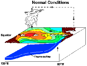
The diagram is an example of changes that are common patterns in the Galapagos. The first diagram is a picture of the ocean during normal conditions, as well as in abnormal conditions such as in El Nino.
Note: the white arrows indicating the direction of the Trade Winds (from east to west in normal conditions and reversing from west to east in El Nino conditions). In many El Ninos the Trade Winds may not actually reverse, they just slow down or stop. Also notice the depth of the thermocline (shallow area near the Galapagos in normal conditions) it has been leveled, creating the oceans water bed to rise.
Source: http://www.marinebio.net/marinescience/02/englobe.htm
  |
| Source: http://www.marinebio.net/marinescience/02ocean/englobe.htm |
| |
Roxana -
ReplyDeleteYour choice of location really piqued my interest because I've always wanted to dive the islands.
You are very succinct and to-the-point. Every point you make is substantiated by an image that either graphically represents the data or shows what you are describing with the use of arrows. This makes the post easy to read.
My only concern is that you initially described the climate as "predominantly warm and dry," but you state that because of the warm currents that flow into the region, the islands' humidity rises because the currents warm the air. I was just curious how an environment with an average temperature that stays within a margin of about +-6 degrees of the median can have such drastic effects on the humidity.
But overall, nice job! Because your blog is media-rich, it actually helped me understand your points really clearly. I look forward to reading your next post.
I found your location to be very interesting. The use of all of the media was very helpful. I found that you did a really good job explaining the humbolt and panama currents effect on the Galapagos very well.
ReplyDelete