Paths of Ocean Currents

Affects of climate change on the Galapagos Islands
To determine climate in the Galapagos temperature and percipience are tow key factors.
1.Temperature:
 | ||||||||
| 2.Percipience: |  | ||||||||||||
 |
| source: http://www.pmel.noaa.gov/tao/elnino/impacts.html |
The Inter-Tropical Convergence Zone (ITCZ) helps guide the path of the oceans currents in the Galapagos region. The ITCZ results from convergence of the Humboldt and Panama Currents which flow through the Galapagos region.


- Humboldt Current-December through June the Humboldt Current slows down allowing the east trade winds to bring in the warmth.
- Panama current- The Humboldt current also brings in poor nutrient water along with the Panama current.
El Nino is a wide ranging climate pattern, which results in altered ocean currents in the Galapagos region. During El Nino, the Galapagos experience increased sea surface temperatures and a decrease in nutrients.
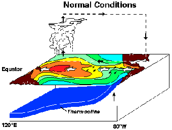
The diagram is an example of changes that are common patterns in the Galapagos. The first diagram is a picture of the ocean during normal conditions, as well as in abnormal conditions such as in El Nino.
Note: the white arrows indicating the direction of the Trade Winds (from east to west in normal conditions and reversing from west to east in El Nino conditions). In many El Ninos the Trade Winds may not actually reverse, they just slow down or stop. Also notice the depth of the thermocline (shallow area near the Galapagos in normal conditions) it has been leveled, creating the oceans water bed to rise.
Source: http://www.marinebio.net/marinescience/02/englobe.htm
  |
| Source: http://www.marinebio.net/marinescience/02ocean/englobe.htm |
| |